- The details for Long Island are in the forecast below, but it will be humid Friday and Saturday with showers and thunderstorms mostly later afternoon on Friday into the night with more showers and possibly a thunderstorm on Saturday.
- Above average temperatures next week and near average temperatures next weekend (June 4th/5th).
- Watching the Gulf of Mexico in early June for the potential for our first tropical storm of the season (see last image)
LONG ISLAND FORECAST:
Today: Mostly sunny with high clouds with highs around 70 degrees in Nassau and mostly upper 60's in Suffolk, but cooler for the south shore and east end. Wind out of the E at 5 mph in the morning and then out of the SE at 10 to 15 mph by late afternoon.
Tonight: Partly cloudy with lows in the mid 50's in Nassau and mostly low 50's in Suffolk. Wind out of the SE at 5 to 10 mph.
Tomorrow: Partly cloudy with increasing clouds late with highs in the upper 60's, but cooler for the south shore and east end. Wind mostly out of the SE at 5 to 10 mph in the morning and SSE at10 to 15 mph in the afternoon.
Tomorrow night: Mostly cloudy with a 30% chance of a few showers with lows mostly near 60 degrees. Wind out of the S at around 10 mph.
Friday: Cloudy and humid with a slight chance of a morning shower and then breezy with showers and possibly a thunderstorm later in the afternoon into the evening with highs in the low to mid 70's. Wind out of the S at 10 to 20 mph.
Saturday: Showers likely in the morning and then mostly cloudy and humid in the afternoon with scattered showers and possibly a thunderstorm with highs in the mid 70's, but cooler for the south shore and east end. Wind out of the SW at 10 to 15 mph.
Sunday: Mostly cloudy in the morning with a slight chance of a shower and then partly cloudy in the afternoon with highs in the mid 70's, but cooler for the south shore and east end. Wind out of the NNE in the morning and SE by late afternoon at 5 to 10 mph.
Monday: Mostly sunny with highs in the mid to upper 70's, but cooler for the south shore and east end. Wind out of the E at 5 to 10 mph.
Tuesday: Mostly sunny with highs around 80 degrees in Nassau and mostly in the upper 70's in Suffolk, but cooler for the south shore and east end. Wind out of the SSW at 10 to 15 mph.
- 1st image: My 5 day outlook for Long Island
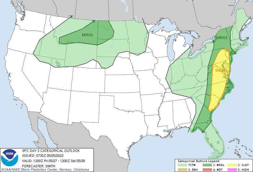
- 2nd image: Severe weather potential for Friday and Friday night from the SPC
- 3rd image: Projected temperatures with ranges for Long Island for the next 15 days from the Euro ensembles
- 4th image: Projected temperatures for Long Island for the next 10 days from the NWS Model Blend
- 5th image: Storms tracks for the next 15 days from the Euro ensembles