- An incredibly strong magnitude 8.2 earthquake occurred 56 miles off the southern coast of Alaska with strong aftershocks. A Tsunami Warning is in effect for parts of Alaska. From Dr. Lucy Jones just now: "The M8.2 Alaska quake is on the subduction zone interface. That means the seafloor under the Pacific Ocean is being pushed under the Alaskan peninsula. It also means it generated a tsunami. There is a Tsunami watch for the West Coast. The warning for Hawaii has been cancelled, because the waves are focused east of Hawaii and the event isn't that large. This location is not a surprise. I led a USGS project to model a bad tsunami for Los Angeles and we put the model location at the same place. It is just west of the 1964 quake and historically hadn't had much activity. But our modeled quake was bigger. The main impacts for this M8.2-produced tsunami will likely be strong currents in harbors on the West Coast of the United States. The first wave will arrive during the night hours, but later arrivals could cause strong currents all day."
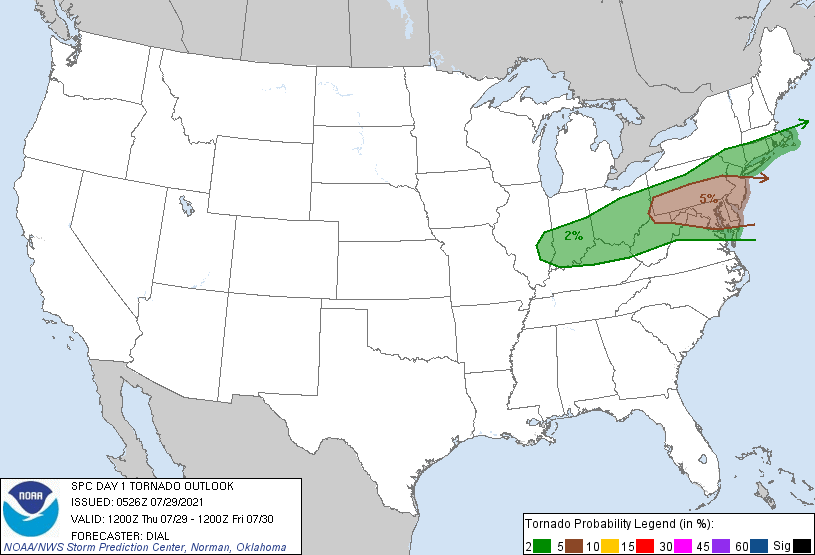
- Nassau and southwestern Suffolk have been upgraded to the slight risk (yellow zone) for severe thunderstorms later today into tonight. The main threat would be damaging wind gusts and possibly hail, and even a tornado can't be ruled out. It looks like the best chance for the heavy showers and thunderstorms would be between 4 PM and 10 PM for Long Island, but there will likely be some scattered coverage before and after that time period.
LONG ISLAND FORECAST
Today: Increasing clouds and humid with showers and thunderstorms becoming more likely by late afternoon and evening with the potential for heavy downpours and strong gusty winds. Also, hail and a weak tornado cannot be ruled out. Highs in the mid to upper 70's. Wind out of the S at 10 to 20 in the afternoon.
Tonight: Humid with showers and potentially strong thunderstorms with lows in the upper 60's. Wind out of the S to SSW at 10 to 20 mph.
Tomorrow: Mostly sunny and breezy with lower humidity in the afternoon with highs in the low 80's. Wind out of the NW at 10 to 20 mph with gusts up to 25 mph in the afternoon and evening.
Saturday: Sunny with low humidity with highs in the upper 70's. Wind out of the W to NW at 5 to 10 mph.
Sunday: Increasing clouds with a chance of some showers by late afternoon with highs around 80 degrees. Wind out of the S to SSW at 10 to 15 mph in the afternoon.
Monday: Mostly sunny with low humidity in the afternoon with highs mostly around 79 to 82 degrees. Wind out of the NNW at 5 to 10 mph.
- 1st image: My 5 day outlook for Long Island
- 2nd and 3rd images: Earthquake and Tsunami info
- 4th and 5th images: Severe weather potential for today into early tomorrow morning
- 6th and 7th images: Tornado and damaging wind gust potential for today into early tomorrow morning
- 8th to 10th images: Future radar from the HRRR model for 4 PM , 8 PM, and 2 AM, respectively
- 11th image: Future radar from the NAM model for 6 PM
- 12th image: Projected temperatures for Farmingdale, Long Island for the next 10 days from the NWS model blend