


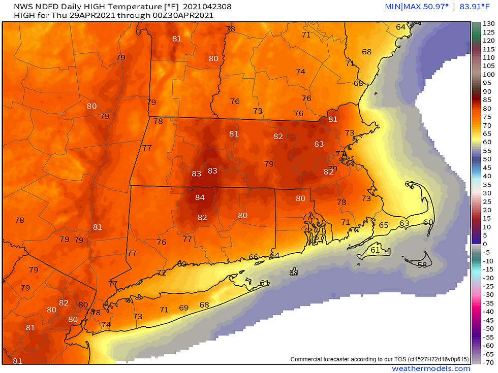
Check out the temperatures for Thursday with 80's away from the coast (1st image):
- My Personal Weatherman™

- Apr 23, 2021
- 2 min read
The details for Long Island are in the forecast below, but there will be a big warm-up for Wednesday and Thursday next week. As for the rain this weekend, it will start just after midnight tomorrow night and end between around 2 PM and 4 PM Sunday from west to east with close to one inch of rainfall. Rainfall amounts will decrease as you head north, northwest, and west of Long Island (see maps below).
LONG ISLAND FORECAST:
Today: Sunny and windy still with highs in the low 60's but cooler with temperatures in the 50's for the south shore and east end. Wind gusts up to 25 mph from the W.
Tonight: Mostly clear skies with lows in the mid 40's. Wind out of the W at 10 to 15 mph.
Tomorrow: Sunny in the morning with increasing clouds in the afternoon with highs mostly in the mid to upper 60's, but cooler for the south shore and east end. Wind out of the W in the morning at around 10 mph and then out of the SSW in the afternoon at around 15 mph.
Tomorrow night: Cloudy with rain developing between around midnight and 3 AM from west to east. Lows mostly in the upper 40's. Wind out of the S at around 10 mph.
Sunday: Rain tapering off to showers and ending by around mid-afternoon from west to east with some breaks of sun possible by late afternoon, especially in Nassau, and it will become windy in the afternoon. Highs mostly around 60 degrees. Wind mostly out of the ENE in the morning at 10 to 15 mph and then out of the N and then NNW by late afternoon with gusts up to 25 mph.
Sunday night: Becoming mostly clear with lows in the low 40's. Breezy with gusts up to 25 mph from the NW.
Monday: Mostly sunny and breezy with highs mostly in the low 60's, but cooler for the south shore and east end. Wind gusts up to 20 mph from the NW.
Tuesday: Mostly sunny with highs mostly in the mid to upper 60's, but cooler for the south shore and east end. Wind out of the SSW in the afternoon at around 10 mph.
Wednesday: Partly cloudy and warm with highs mostly in the low to mid 70's, but cooler for the south shore and east end. Wind out of the SSW to S at around 10 to 15 mph in the afternoon.
Thursday: Partly cloudy and warm with highs mostly in the low to mid 70's, but cooler for the south shore and east end. Wind out of the S at 10 to 15 mph in the afternoon.
- 1st image: Projected highs for Thursday from the National Weather Service
- 2nd image: My 5 day outlook for Long Island
- 3rd image: Projected temperatures with ranges for Long Island for the next 15 days from the Euro ensembles
- 4th and 5th images: Projected rainfall through 8 PM Sunday from the Euro ensemble mean and National Weather Service, respectively
- 6th and 7th images: Severe weather potential for today and tomorrow, respectively, from the Storm Prediction Center
- 8th to 10th images: Maps from the NAM for Sunday at 2 AM, 8 AM, and 2 PM, respectively


Comments