


Rain/snow, then cold, still watching offshore Sunday storm and the latest on the Black Friday storm:
- My Personal Weatherman™

- Nov 15, 2022
- 3 min read
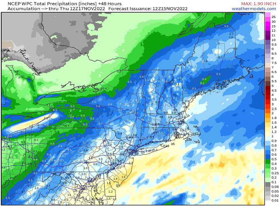
- I have included the snow and precipitation maps for the storm for later today into tomorrow. The details for Long Island are in the forecast below, and it looks like roughly around one inch of rain. It will also be breezy/windy tonight with gusts up to 25 to 30 mph. Regarding temperatures tomorrow morning, it will be mild, especially just east of the center of the storm which should cross Long Island, so southeastern Suffolk has the best chance to hit 60 degrees with 60 degree dew points tomorrow morning. Temperatures will then drop as the storm pulls away.
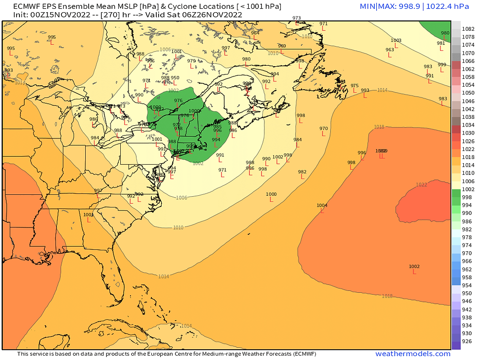
- The Sunday storm still looks like it should stay well offshore, but it's too early to dismiss it completely as some ensembles still bring rain/snow for the coast. The best chance might be for DownEast Maine, but I will keep posting about this.
- If the Sunday storm misses us, we will likely be basically dry for the 8 days from this Thursday through Thanksgiving.
- It will be a very cold weekend and Monday with lows in the 20's and highs mostly near 40 degrees. High pressure will be centered over the northeast early next week, but as it shifts east we will gradually moderate, and on Thanksgiving we could make it into the low 50's.
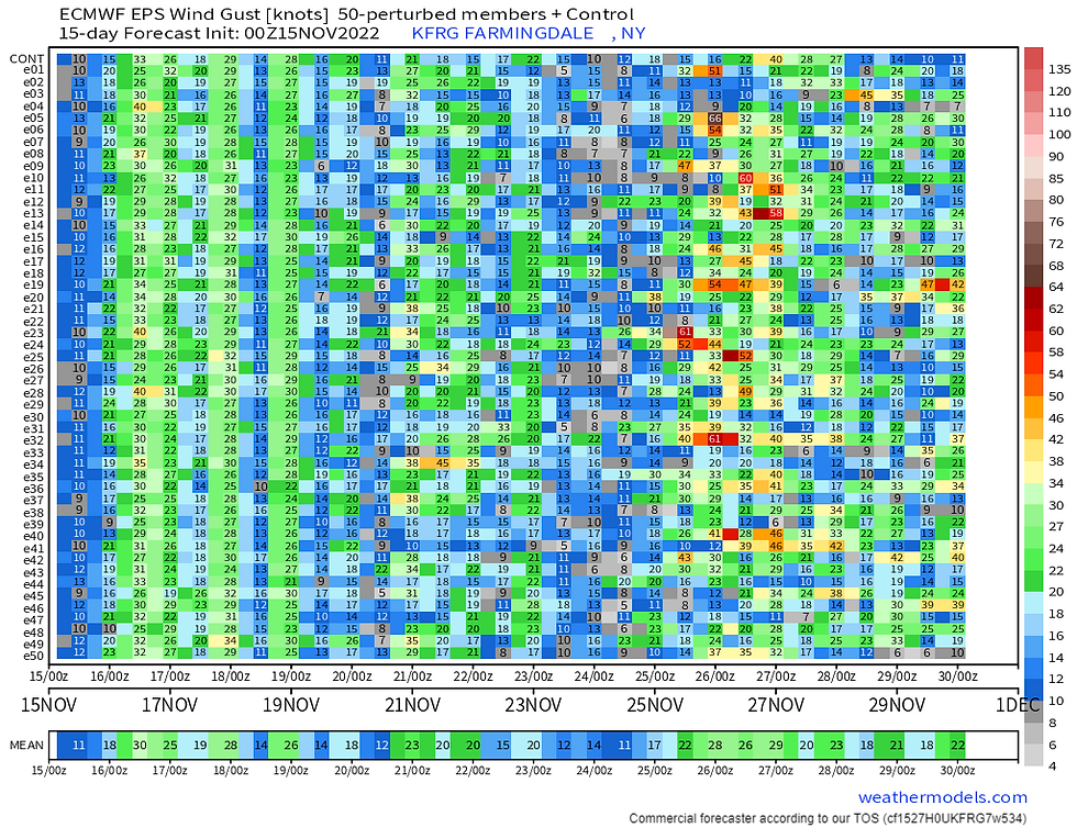
- Then there are strong signals for a big storm on Black Friday into early Saturday with rain likely for Long Island, and the Euro ensembles continue to show the potential for wind gusts of 45 to 60 mph! I will continue to watch it and update.
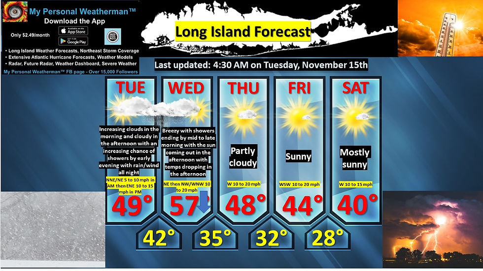
LONG ISLAND FORECAST:
Today: Increasing clouds in the morning and cloudy in the afternoon with an increasing chance of showers by early evening with highs in the upper 40's. Wind out of the NNE to NE at 5 to 10 mph in the morning and then ENE at 10 to 15 mph in the afternoon.
Tonight: Rain arriving in the early evening and continuing all night and become windy with lows in the low 40's and rising towards morning. Wind out of the ENE and increasing to 15 to 20 mph with gusts close to 30 mph after midnight.
Tomorrow: Breezy with showers ending by mid to late morning with the sun coming out in the afternoon with morning highs in the mid to upper 50's (60 degrees possible in eastern Suffolk) and then temperatures slowly dropping in the afternoon to around 50 degrees. Wind out of the NE then NW /WNW at 10 to 20 mph.
Tomorrow night: Partly cloudy with lows in the mid 30's. Wind out of the W at 10 to 15 mph.
Thursday: Partly cloudy with highs in the mid to upper 40's. Wind out of the W at 10 to 20 mph.
Friday: Sunny with highs in the mid 40's. Wind out of the WSW at 10 to 20 mph.
Saturday: Mostly sunny and cold with highs only around 40 degrees. Wind out of the W at 10 to 15 mph.
Sunday: Mostly sunny and cold but watching a potential offshore storm, but it should stay well offshore as of now. Highs in the low 40's. Wind out of the W at 10 to 20 mph.
Monday: Mostly sunny and cold with highs only around 40 degrees Wind out of the WNW then W at 10 to 20 mph.
- 1st image: My 5 day forecast for Long Island
- 2nd image: Projected temperatures for Long Island for the next 15 days from the Euro ensembles
- 3rd and 4th images: Snow and precipitation maps from the NWS and WPC through tomorrow
- 5th image: Projected storm locations and strengths from the Euro ensemble members at 1 AM on Saturday, November 26th
- 6th and 7th images: Snow and wind matrices for Long Island for the next 15 days from the Euro ensembles


Comments